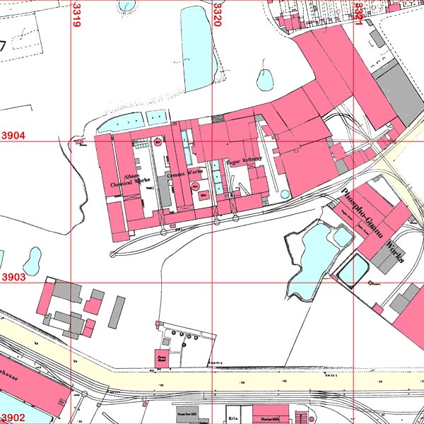
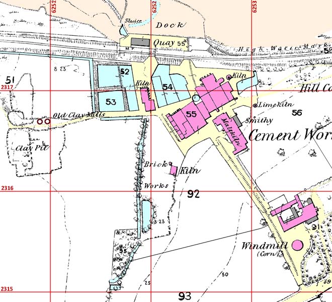
The production of maps by the Board of Ordnance began around the start of the 19th century, initially for defence purposes, resulting in maps at 1 inch ≡ 1 mile (1:63360) scale. These maps had far too small a scale to represent the detailed outline of buildings, and after the mapping function was transferred to the War Department in 1855, the decision was made to make much more detailed maps for most of the country as a "base-scale" from which other smaller-scale maps could be derived. In 1858, it was decided that the base-scale should be 1:2500 (although 1:500 was used in some urban areas). Surveying at these scales began in 1862. The 1:2500 maps were produced for individual counties - and, in fact, in the first edition, for individual parishes. These maps are today referred to as the First Edition County Series. The results of the initial surveys began to be published in the late 1860s. At the time of these developments, the production of Portland cement was in its infancy, so a rather limited set of Portland-cement-making sites are depicted on the maps published in the 1860s.
After an initial flush of enthusiasm for the product, progress remained slight during the 1850s, perhaps because the initial scepticism of many potential users was born out by poor product made by new entrants. However, from 1860, a period of fast growth began, Portland cement's virtues having been extolled by the Metropolitan Board of Works.
All the plants depicted here used soft raw materials, and used the classic wet process developed by James Frost and William Aspdin. In this, raw materials were ground to a wet slurry in a washmill. The slurry was transferred to slurry backs to settle. The resulting "slip" was dried on drying flats. The dried material was placed in bottle kilns with alternate layers of coke and burned to a clinker. The clinker was then crushed and ground to cement using flat stone mills.
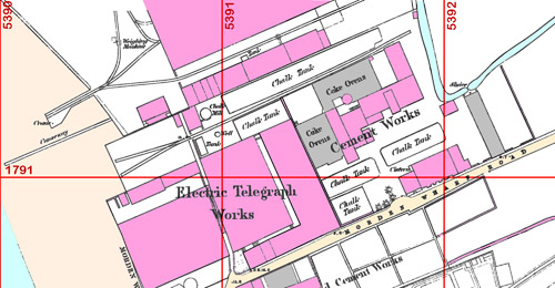
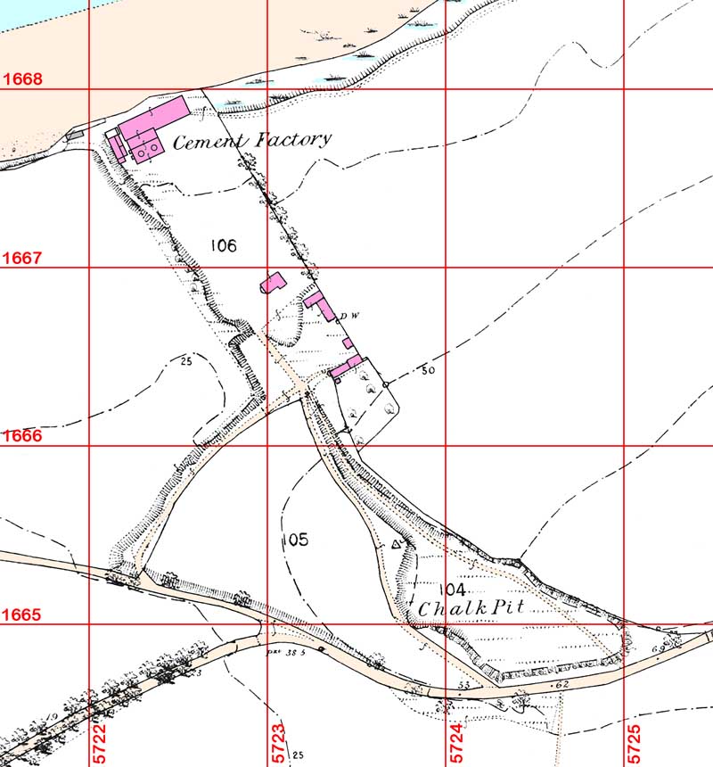
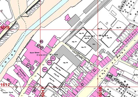
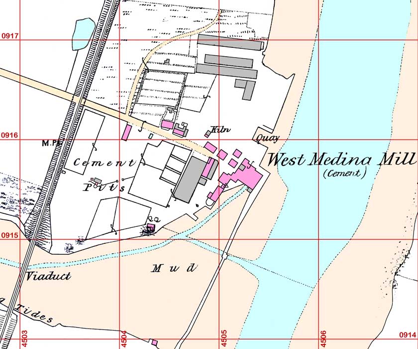
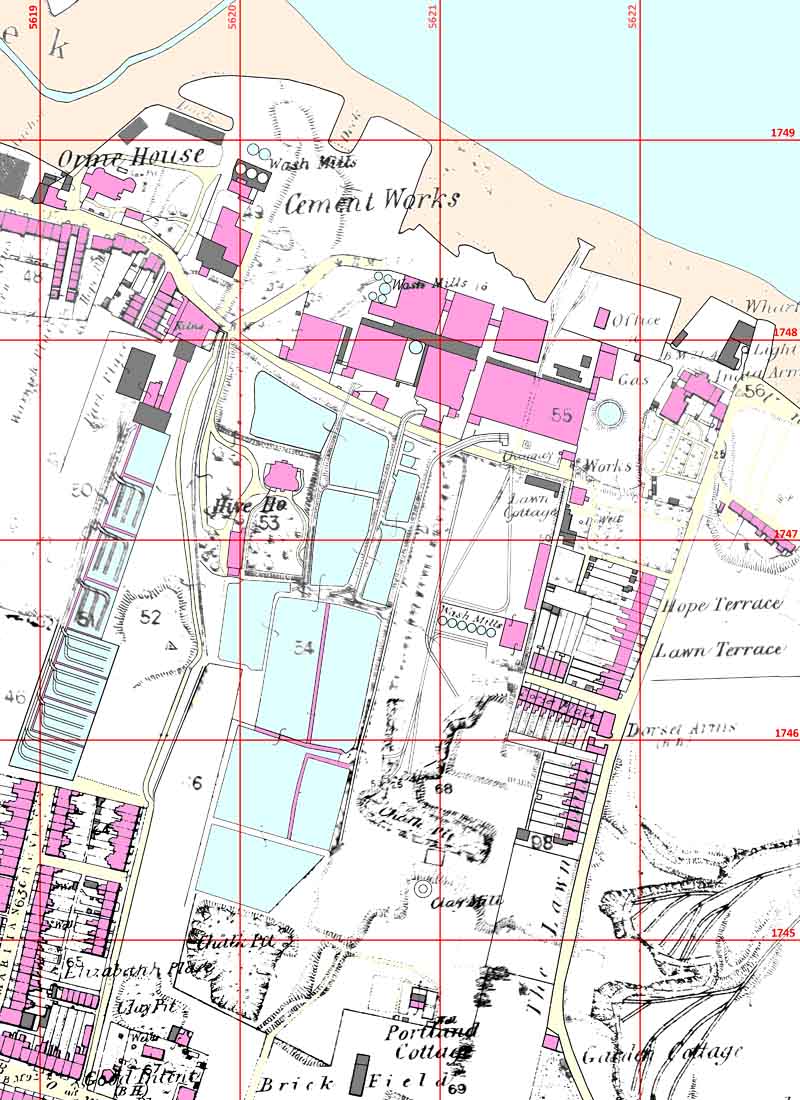
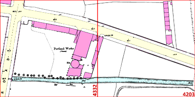
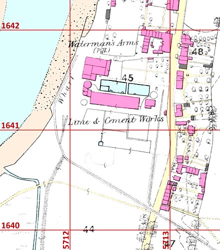
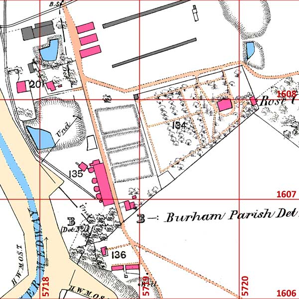
Here, maps are shown as presented on the original print, edited and re-aligned to conform with the modern National Grid coordinate system, at a scale of 2 pixels per metre. Grid lines are shown at 100 m intervals. The sites are placed in chronological order of start-up, and an attempt is made to describe the path of technology transfer.
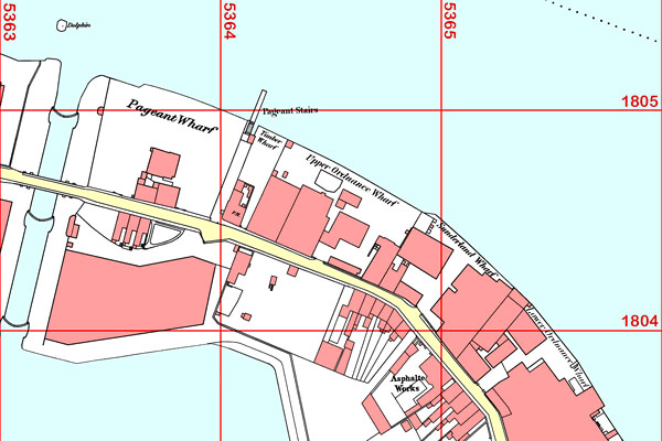
Surveyed at 1:1056 in 1868. Redrawn from the OS County Series first edition 60 inch map sheets London VII.79&80, surveyed 1868, and adjusted to National Grid orientation as on OS 1:2500 TQ3680 surveyed 1949. Reproduced with the permission of the National Library of Scotland, subject to this Creative Commons Attribution-NonCommercial-ShareAlike (CC-BY-NC-SA) licence.
At this site, William Aspdin first made Portland cement (as we know it today) commercially in 1842. No detailed map appears to have been produced of the area prior to 1868, and Aspdin left 22 years earlier. The wharves were on a narrow strip of land served by Rotherhithe Street, between the Thames to the north and the timber ponds of the Surrey Docks to the south. There is no obvious remnant of Aspdin's activities shown. Some contemporary small scale plans indicate that the area towards the wharf was largely clear, and his three kilns were probably midway between the wharf and Rotherhithe Street.
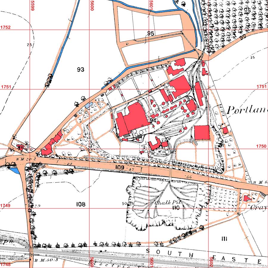
The site was originally developed in 1825 by James Frost as a source of chalk for making his British cement as a substitute for Roman cement. In 1833, Francis and White took over the plant and continued making those products. In 1845, their manager I C Johnson finally managed to copy Aspdin's product. Johnson left in 1851, and the plant came under the management of William Goreham. By 1864, the plant was making 30,000 t a year, mainly for export.
This site was originally used by Parker & Wyatt for their Roman cement; they were attracted to the site by the availability of the tidal mill on the Ebbsfleet Creek for grinding the product. The mill itself was of medieval origin. William Aspdin relocated to this site from Rotherhithe to make Portland cement in 1846, attracted by the existing grinding equipment and the availability of chalk on-site. He constructed his plant to the east of the old mill, erecting five kilns, and eventually transferring a steam engine from the Rotherhithe site for wet and finish milling. After Aspdin was ousted in 1851, R A Gibbons became manager. By 1863, he had erected two more kilns at the old plant, and had begun relocating the main plant operations to the west side of the creek with another bank of kilns.
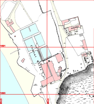
I C Johnson left John Bazley White in 1851. He was presumably already acquainted with George Burge and his son, and with them had selected this site. There was an existing steam powered oil mill, and existing chalk quarries, so slurry backs, drying flats and kilns were erected. Having set up the plant and put it in the hands of Burge junior, Johnson left in 1854 to set up the Cliffe Creek plant. In Burge's hands, the plant's output tailed off for the next few years, as did others he promoted. However in 1858, Burge commenced expanding the plant, adding a fifth slurry back and more kilns by 1862, and took up residence at Quarry House. He continued to install the technology he learned from Johnson at many other sites in the area.
This tiny site was taken by Henry Reid with the backing of John Winkfield to make Portland cement in 1852. How Reid obtained the technology is uncertain, but it is possible that Reid was one of the "persons unknown" with whom William Aspdin conspired, according to John Henry Cox. Reid remained in place until 1867, when the plant was bought by Ashby & Son.
Edwin Hollick started the plant with the technical assistance of George Burge Jnr. The map shows no slurry backs but does show a washmill. Slurry backs were situated between the washmill and the kiln (Note 1). The map shows that no expansion had occurred before 1865 and the plant may have ceased operation. Expansion only started after Booth took over in the following year.
This very urban site was one of the earliest (1816) Roman cement manufacturing sites, set up by local worthy Samuel Shepherd. It was taken over by C J Hilton in 1849, and Portland cement equipment was added, with the aid of George Burge Jnr, although the site continued to produce Roman cement. On this early map, the cartographer labels the many slurry backs as "clay pit". The site was too cramped to expand much, and although close to sources of septaria for Roman cement, chalk was less accessible, so the company set up Upnor in 1859 for further expansion of its Portland production.
I currently have no early map for this site. The First Edition Durham Sheet III.13 was surveyed as early as 1857, and there may be a Town Plan as well. The NLS catalogue for this area is incomplete. Next time I'm in London.
William Aspdin moved to this site in 1852, following his ejection from Robins, adopting advice from contacts in the area's coal trade. The site had the benefit of an existing steam-powered flour mill, ballast hills and a soap works for raw material, cheap coke and a deep-water wharf. In 1854, his collaborator G T Gibson called in Johnson to arbitrate on a dispute, as a result of which, Aspdin was made bankrupt and the plant was closed. Johnson moved here in 1856 and reopened the plant. Aspdin's next move (1856) was to build the plant at Ouseburn.
A tidal mill was erected on the site in the 1790s for the owners, Queen's College, Oxford. The mill was leased by Francis & Son to make Roman cement from locally-dredged septaria, around 1840. They commenced Portland production in 1852, using the technology developed by Johnson for John Bazley White. By 1862, the plant was still focused on the tidal mill, but had expanded with steam power and large areas of slurry backs. The old mill, capable of producing 100 kW or so for short bursts on spring tides, was probably reserved for Roman cement grinding.
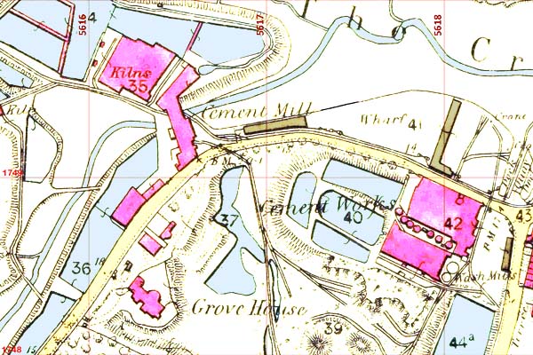
The freehold estates of Orme House and Hive House in Northfleet were in 1808 acquired by the government Commissioner of Works to build a naval dockyard, and after the plan was abandoned, whalers George and Thomas Sturge bought them in 1837, mainly for their river frontage. They developed the existing brick works on the site. Some time in the late 1840s, they were approached by William Aspdin, who leased the adjacent site on the Creek, regarding setting up a Portland cement plant. This may have been simply to extend available chalk land for his own operation, or may have been a deliberate spoiler to compromise its future after his departure. Either way, the Sturges, who were already in the Roman cement business elsewhere, took up the offer and commenced building the plant. The brothers retired around the time the plant started, and in 1854, a partnership was formed between their nephew Alfred Sturge, J M Knight and Thomas Bevan. Knight, in particular, provided a lot of development capital, and during the late 1850s the plant was massively extended. Alfred Sturge died in 1859, leaving the operation of the plant in the hands of Bevan. The plant by 1864 was very large, clearly exceeding the size of Swanscombe, and had a large amount of workers' tied housing on parts of the estate. It subsequently expanded only marginally, and Swanscombe quickly re-established its lead in size and production.
As on some other maps of the time, the slurry backs are shown as if water-filled. The map shows two distinct phases of development; the older plant on the Orme House tract (between College Lane - then called Onetree Lane - and Hive Lane) and the newer plant on the Hive House tract (between Hive Lane and Lawn Road). Both tracts extended far to the south, across the High Street to the Ebbsfleet, forming a vast freehold resource.
There is no early OS map of this plant; the first edition was surveyed in 1848, and it was not shown on the map. It had probably not changed much by the time of the second edition. Joseph and James Aspdin were driven out of their Pear Tree Close plant site in 1848 by a compulsory purchase order to expand the railway station sidings, and moved to Ings Road. James presumably got the technology for the new product from his brother William, but this may have happened much later, and at present it can only be said that production of "Portland cement as we know it" was introduced here some time between 1853 and 1870. The row of slum cottages to the east was called Portland Place.
Thomas Freen made lime at this site. After his death in 1845, the family partnership converted it for Portland production with the aid of George Burge Jnr in 1853, but went bankrupt in 1855, perhaps as a direct result. Burge stepped in and ran it until 1859, after which it shut down, and remained shut at the time of this map. In 1863 A D Robertson, with capital to spare, took it over and re-started it.
Thomas Cubitt selected this site as a convenient source of Gault Clay for brickmaking, and by 1852 had a brickworks in operation. This rapidly expanded to a large size. Almost as an afterthought, a small cement plant was built, designed to use the slurried Gault as a raw material. There was no chalk available on-site, so chalk was brought from various sources further downstream. Cement production began around 1854, but the lack of any development by 1865 shows that it was of low priority, or even abandoned as a "neat idea" that failed, as typified by the earlier Borstal Court and Wouldham Court. It must be assumed that George Burge Jnr originally proposed the idea and provided designs. The plant was taken over by Webster & Co. in 1859, and expansion began in the late 1860s, at which point a chalk quarry was developed in the valley side at Culand, 2 km to the northeast.
The map shows the small plant occupying only about a hectare, with part of the brickworks that extended to the north, while the main Gault quarry was to the northeast. Rose Cottage, with its extensive grounds, housed the manager of both sites.
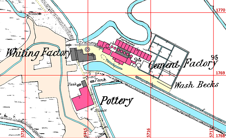
Around 1790, a chalk quarry had been opened by a local landowner, complete with a canal across the marshes to transport chalk to the Thames. A whiting plant was established at the point where the canal met the creek. When Johnson parted with Burge, he leased land adjacent to the whiting works, and some of the quarry land, with finance from John Poynter. The plant was expanded in 1856 with finance from John Osmotherly. The plant was immediately in difficulties, and was probably idle in 1861, but was revived soon after. Johnson moved to Gateshead in 1856, making that his main business.
The map marks the slurry backs as "wash becks" - a term used only by Johnson (Note 2).
The site was previously used as a brickworks, for which the dock was constructed. In 1854, William Levett commissioned George Burge Jnr to convert it for Portland cement manufacture, with Roman cement as a sideline. The plant in 1864 remained as originally converted, with four small Portland kilns.
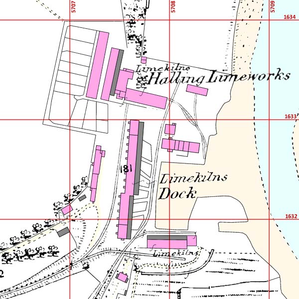
William Lee commenced making lime at Millbay across the river in 1826, and moved to this site in 1846. His firm was the largest supplying Medway grey lime to the London market, using the Chalk Marl at the foot of the North Downs escarpment. He obtained help from George Burge Jnr to commence making Portland cement in 1854, being the first to use Grey Chalk for this purpose. Unlike Burge's other projects on the Medway, it did not falter, Lee having the ability to market in London and a strong relationship with the Metropolitan Board of Works, and by 1864 there were nine kilns operating, although the plant remained primarily a substantial lime works.
The cement plant was in the northwest of the site. The map labels the cement kilns as lime kilns, but the logical arrangement of slurry backs, drying flats, kiln bank, mill house and cement store is plain to see. The plant was unique among sites mentioned thus far in having a siding connected to main line rail - the Strood-Maidstone branch of the South-eastern Railway was opened in 1856 - although water transport remained its main outlet.
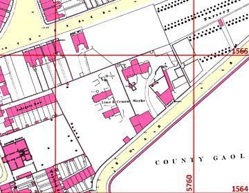
This tiny urban plant with two lime kilns and a Portland cement kiln functioned intermittently, presumably for a local market. It advertised both Roman and Portland cements, and had a washmill, slurry backs and a drying shed for the latter. It had no on-site raw materials and might have brought chalk by road from the downs, or from the nearby river wharf. Two or three tons a day would have kept it going. The source of the technology is obscure - it might have been a defector from any of the plants down the river. Following convention, the prison on the opposite side of the road is not shown.
Construction of the sugar refinery at this site was started in 1852, but it was on sale in 10/1854 before it had started production. In 10/1855 it was operating in the hands of Littledale & Taylor, as was the cement plant, originally using the sugar refinery waste as raw material. The sugar refinery was bankrupt in 1865, and cement production continued intermittently, with various owners, using a variety of other waste materials. At liquidation in 1871, it had two kilns, ovens, grinding and washmills.
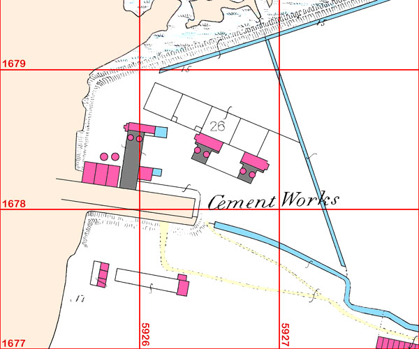
A lime works was operating at this site around 1830. In 1855, it was leased by Thomas Weekes, with finance from T H Boorman and T M Wild to make Portland cement. Weekes was involved in the Medway barge trade and was familiar with the plants already in operation on the Medway.
John Pattrick owned the corn mill. In an area rich in septaria, he began making Roman cement in the 1820s. He commenced making Portland cement in 1856, using chalk and clay from the Medway brought as return loads on barges taking Harwich septaria to the plants in Kent, and presumably acquired the technology from the many pupils of Burge at the North Kent plants he dealt with. He lived at Hill House, next to the mill.
A lime works had previously existed at this site. On his ejection from Gateshead in 1856, William Aspdin set up a three-kiln Portland plant here, with finance from William Jackson. The plant scarcely started before he and his family were pursued by creditors and fled to Germany. The plant reverted to making Roman cement until the late 1860s.
NOTES
Note 1. A sceptic might suggest that the map shows that Portland cement had not been produced at this site by 1865. Francis and others give the date 1852, based on APCM records, and imply that PC was made, but this is not explicitly stated. Such question marks hang over many early plant histories.
Note 2. Johnson used the term in his autobiographical accounts. Where he got the term is unclear; his first experience of slurry backs was at Swanscombe, and they were never called becks there, nor were they, so far as I know, on the Tyne. The OS must have obtained the term from him. In general, the OS did not refer to plant staff when labelling items of equipment, and frequently mis-identified them . At Ashby's slurry backs are called "chalk tanks"; at Faversham, "clay pits"; at Vectis, "cement pits", while in all other early-plant instances they are not labelled at all.